- While India lodged a strong protest against China’s claims, Nepal, Vietnam, Malaysia, and Taiwan have expressed strong objections to China’s new map.
- UN tribunal had already invalidated China’s earlier claims, deeming them without merit in international law.
- India must strongly protest against international organizations, such as the World Health Organization and the World Economic Forum, that perpetuate inaccurate maps of India. Business-as-usual approaches in such circumstances should not be tolerated.
- India should proactively employ social media platforms to counter and promote its cartographic perspectives in a measured manner, in collaboration with cartographic scholars, security experts, and social media content curators.
A storm of controversy has swept across the South China Sea and India, all stemming from China’s release of a new ‘official map’ that reasserts its territorial claims over the majority of the sea. This map also introduces additional territorial assertions along the Indian border, igniting outrage in its wake.
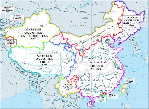
The map in question, referred to as the “new standard” map by China’s Ministry of Natural Resources, resuscitates the contentious 9-Dash Line claims that were previously rejected by the United Nations’ Law of the Sea tribunal. In a bold move, it extends China’s territorial claims to encompass regions near Taiwan and to the north of India. This development follows President Xi Jinping’s recent declaration at the BRIC summit that “hegemonism is not in China’s DNA.”
India has been at the forefront of the uproar, as China unilaterally claimed two new regions, drawing the ire of both India and Nepal. Yet, India is not alone in its concern.
China’s latest claims not only encompass Indian territories like Arunachal Pradesh and Aksai Chin but also extend into Russian territory, specifically Bolshoy Ussuriysky Island. Moreover, there’s speculation that the way China demarcates its claims near Taiwan may imply ambitions over Japanese islands in the Ryukyus. These assertions of Russian and potential Japanese territory represent new and significant developments. While India has formally protested China’s actions, Japan is likely to seek clarification, given the delicate geopolitical balance. Russia’s response remains uncertain, as Moscow may weigh the importance of Beijing’s support in the ongoing Ukraine conflict.
As is customary in the Indo-Pacific region, experts offer varying interpretations of these events. Ian Chong, an associate professor at the National University of Singapore, notes that while these claims aren’t new, their timing is surprising. Speculation abounds regarding the motives behind China’s actions, including its response to reports of Chinese vessels using water cannons to obstruct vessels from the Philippines and Vietnam. It could also be linked to Vietnam and India aligning themselves with the 2016 arbitral tribunal ruling that disputes China’s expansive claims in the South China Sea.
Objections to China’s New Map
Reactions have been swift and resolute, with India, Nepal, Vietnam, Malaysia, and Taiwan all expressing strong objections to China’s new map. India has lodged a formal protest against China’s claims, underscoring the long-standing border disputes that have led to clashes between Indian and Chinese troops.
In Malaysia, China’s delineation of portions of Malaysian waters near Sabah and Sarawak as Chinese territory was met with firm rejection. The Philippines also firmly rejected China’s new map, citing violations of international law, particularly the United Nations Convention on the Law of the Sea (UNCLOS).
China’s response has been consistent, with its Foreign Ministry emphasizing that these standard maps are routinely published to promote their standardized use and public awareness. Nevertheless, this move has prompted concerns and questions about China’s intentions, given the contentious history of its territorial claims and actions in the region.
China’s latest map officially establishes its 10-Dash Line, an expansion from the previous 9-Dash Line. It’s worth noting that the UN tribunal had already invalidated China’s earlier claims, deeming them without merit in international law. Consequently, China has undertaken controversial actions, including the destruction of coral reefs to construct military installations and confrontations with foreign vessels and aircraft in international waters and airspace.
Checkmate China in its own game!
A proactive stance on the diplomatic front is paramount. Instead of reacting to instances of cartographic aggression, India should proactively protect the inviolability of its territorial integrity. The issue of inaccurate map representation should be raised with friendly countries, beginning with the QUAD, and protests should be launched against international organizations that perpetuate such misrepresentations, such as the World Health Organization and the World Economic Forum. Business-as-usual approaches in such circumstances should not be tolerated. Furthermore, all instances of cartographic misrepresentation should be promptly conveyed to the Ministry of External Affairs and the relevant authorities in host countries to avoid any perception of indifference.
A proactive stance on the international stage is equally vital. Protests must be raised early on when developments in third countries compromise Indian interests, irrespective of whether Indian territory or population is directly affected. India’s assertive stance regarding Hong Kong, which houses a significant Indian diaspora, and the Sakteng Wildlife Sanctuary, which borders Arunachal Pradesh, should serve as models for future responses. Delayed or passive reactions only serve to increase costs for India.
Engaging with international media is another imperative facet of this strategy. India must strive to ensure that Indian narratives, rather than those of its adversaries, are the most accessible and credible sources of information about the country for the global community. To achieve this, Indian representatives, including diplomats and Union Ministers, should engage more actively with international media through personal interviews, discussions, and written contributions. This proactive engagement should supersede the traditional reactive responses to aggressive acts by adversaries.
Additionally, the Indian government should consider sponsoring Indian academics and strategic experts at internationally renowned institutes such as RAND, IISS, and RUSI. This step would expand the reach of Indian narratives within global academic circles. Moreover, the representation of officially recognized Indian maps in publications by these institutes would enhance the visibility of India’s cartographic stance.
In this era of social media, it is essential to recognize that states use these platforms to influence public discourse, including matters related to cartography. While regulating social media platforms presents challenges, India should proactively employ these platforms to counter and promote its cartographic perspectives in a measured manner. This endeavour requires comprehensive planning and a collaborative effort involving cartographic scholars, security experts, and social media content curators. The Public Relations wings of intelligence agencies should play a pivotal role in guiding the content that needs to be curated or countered. This coordinated effort should be led by the Survey of India, in collaboration with the Ministry of External Affairs, Ministry of Home Affairs, and Ministry of Defence.
In conclusion, China’s renewed territorial claims have sparked widespread concerns and protests, adding to the complex geopolitical dynamics in the Indo-Pacific region. These actions raise questions about China’s intentions and its approach to international law and norms.
(The author is a postgraduate student in International Relations at Amity University, Raipur. She writes articles and research papers regularly on international affairs and geopolitics.)