- The Nasa-Isro Synthetic Aperture Radar (NISAR) is a collaboration between the Indian and US space agencies for a dual-frequency L and S-band SAR for earth observation
- The NISAR Mission will measure Earth’s changing ecosystems, dynamic surfaces, and ice masses providing information about biomass, natural hazards, sea level rise, and groundwater, and will support a host of other applications.
- NISAR will observe Earth’s land and ice-covered surfaces globally with 12-day regularity on ascending and descending passes, sampling Earth on average every 6 days for a baseline 3-year mission.
- NISAR is the first satellite mission to collect radar data in two microwave bandwidth regions, called the L-band and the S-band, to measure changes in our planet’s surface less than a centimeter across.
The Indian Space Research Organisation (ISRO) has completed the development of a radar capable of producing extremely high-resolution images for a joint earth observation satellite mission with the National Aeronautics and Space Administration (NASA).
On Sept. 30, 2014, NASA and ISRO signed a partnership to collaborate on and launch NISAR. NASA is providing the mission’s L-band synthetic aperture radar, a high-rate communication subsystem for science data, GPS receivers, a solid-state recorder and payload data subsystem. ISRO is providing the spacecraft bus, the S-band radar, the launch vehicle and associated launch services.
The S-Band SAR was shipped from the Space Applications Centre at Ahmedabad in Gujarat to the jet propulsion laboratory (JPL) at Pasadena in Los Angeles County, California, to be integrated with Nasa’s L-Bank SAR payload.
The NISAR Mission will measure Earth’s changing ecosystems, dynamic surfaces, and ice masses providing information about biomass, natural hazards, sea level rise, and groundwater, and will support a host of other applications.
NISAR is a joint Earth-observing mission between NASA and the Indian Space Research Organization (ISRO) with the goal to make global measurements of the causes and consequences of land surface changes using advanced radar imaging. This mission concept and the resulting partnership are in response to the National Academy of Science’s 2007 survey of Earth observational priorities for the next decade, known as the decadal survey. One of the top priorities identified in this survey was to gain data and insight in three Earth science domains: ecosystems, deformation of Earth’s crust and cryospheric sciences.
NISAR will observe Earth’s land and ice-covered surfaces globally with 12-day regularity on ascending and descending passes, sampling Earth on average every 6 days for a baseline 3-year mission.
NISAR is the first satellite mission to collect radar data in two microwave bandwidth regions, called the L-band and the S-band, to measure changes in our planet’s surface less than a centimeter across. This allows the mission to observe a wide range of Earth processes, from the flow rates of glaciers and ice sheets to the dynamics of earthquakes and volcanoes.
NISAR uses a sophisticated information-processing technique known as synthetic aperture radar to produce extremely high-resolution images. Radar penetrates clouds and darkness, enabling NISAR to collect data day and night in any weather. The instrument’s imaging swath — the width of the strip of data collected along the length of the orbit track — is greater than 150 miles (240 kilometers), which allows it to image the entire Earth in 12 days.
NISAR is planned to launch in 2022 from India’s Satish Dhawan Space Center in Sriharikota, India, into a near-polar orbit. NASA requires a minimum of three years of global science operations with the L-band radar, and ISRO requires five years of operations with the S-band radar over specified target areas in India and the Southern Ocean.
All NISAR science data, L-band and S-band, will be freely available and open to the public, consistent with the long-standing NASA Earth Science open data policy. NASA has chosen the Alaska Satellite Facility Distributed Active Archive Center (DAAC) to host the mission’s data and products.
What is SAR?
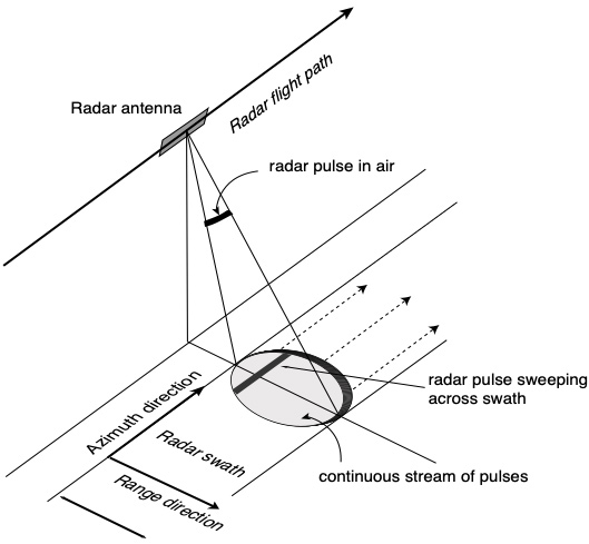
Synthetic aperture radar (SAR) refers to a technique for producing fine-resolution images from a resolution-limited radar system. It requires that the radar be moving in a straight line, either on an airplane or, as in the case of NISAR, orbiting in space.
The basic principle of any imaging radar is to emit an electromagnetic signal (which travels at the speed of light) toward a surface and record the amount of signal that bounces/echoes back, or “backscatters,” and its time delay. The resulting radar imagery is built up from the strength and time delay of the returned signal, which depends primarily on the roughness and electrical conducting properties of the observed surface and its distance from the orbiting radar.
SAR techniques take advantage of the fact that the radar is moving in orbit to synthesize a virtual 10-km-long antenna from the physical 10-m antenna in the direction of flight. As the radar moves along its path, it sweeps the antenna’s footprint across the ground while continuously transmitting pulses – short signal bursts separated by time – and receiving the echoes of the returned pulses.
The NISAR spacecraft will accommodate two fully capable synthetic aperture radar instruments: NASA’s 24 cm wavelength L-band Synthetic Aperture Radar (L-SAR) and a 10 cm wavelength S-band Synthetic Aperture Radar (S-SAR) provided by ISRO. NISAR has a ~ 240 km swath, 7 m resolution along track and 2-8 m resolution cross-track (depending on mode).
In this way, SAR beats the resolution limits of what can physically be put in space to provide images and science of much higher quality than would be possible if the antenna size was used as is.